
A Season That Was Supposed to Be Different
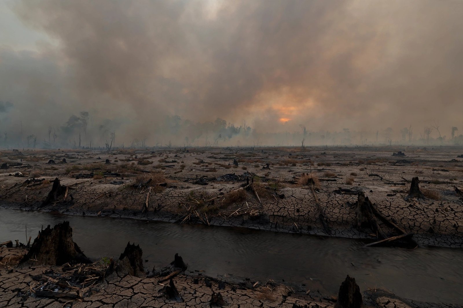
Forest and land fires are not new to Indonesia. They recur in dry seasons, they are overwhelmingly anthropogenic, and they are concentrated in peatland provinces where drainage has converted a waterlogged carbon store into a flammable landscape.The National Disaster Management Agency (BNPB) has stated that 99 percent of land fires in Indonesia are caused by human behaviour, whether through negligence or intentional acts. What distinguishes 2026 is the combination of scale, geography, and timing. Fire activity was exceptionally high not only in the familiar peat provinces of Sumatra and Kalimantan, but also in Indonesian Papua, a region that researchers now describe as a new frontier of deforestation. At the same time, the Amazon experienced a parallel surge, with fire counts tripling in early October even as Brazil reported its lowest annual deforestation since records began in 1988. The simultaneity is not coincidental. It is the signature of a strong El Nino operating on landscapes that have already been made flammable by drainage, fragmentation, and repeated burning.
The analytical task is therefore not to recount a disaster, but to explain why a disaster of this magnitude remained possible after the reforms of 2015 to 2019, and what that explanation implies for climate law. Three questions organise this article. First, what do the 2026 data actually show, and where do different measurement systems disagree? Second, why does peat fire resist the ordinary instruments of fire suppression? Third, what legal and institutional changes would address the causes of fire rather than its symptoms?
The 2026 Season in Numbers
No single dataset captures the 2026 season, and the differences between datasets are themselves analytically significant. Hotspot counts measure thermal anomalies detected by satellite, not fires and not area burned. A single fire can generate multiple hotspots, and underground peat combustion can escape detection altogether. Burned area statistics, published through the Ministry of Forestry SiPongi system, measure a different quantity. Emissions estimates, produced by the Copernicus Atmosphere Monitoring Service (CAMS) and the Global Fire Emissions Database (GFED), model carbon release from satellite observations, vegetation characteristics, and combustion factors. A serious account must therefore triangulate, and must state which measure it is using.
On burned area, Professor Ris Hadi Purwanto of Universitas Gadjah Mada, citing SiPongi data as of October 2026, reported that the total area affected by forest and land fires in Indonesia from 2015 to 2026 reached 8.35 million hectares. That cumulative figure, equivalent to roughly 126 times the area of Jakarta, is a reminder that the present season is the latest episode in a twelve year pattern rather than an isolated event. On current operations, BNPB reported on 13 October 2026 that 639.29 hectares across six priority peat provinces remained under active firefighting, with Central Kalimantan the most severely affected. That figure measures land still being handled by task forces, not cumulative area burned, and it should not be mistaken for the season total. In Riau alone, approximately 20,690 hectares had been recorded as burned by the same date, including 663 hectares of peatland, while Tanjung Puting National Park in Central Kalimantan was reported to have 513 hectares affected.
On hotspots, the Forestry Ministry recorded 7,530 hotspots in Indonesia in October 2026 up to mid month, the highest October figure since 2015 according to SiPongi. On the night of 15 October, 799 high confidence hotspots were detected nationally, an increase of 427 from the previous day. In East Kalimantan, the Meteorology, Climatology and Geophysics Agency (BMKG) recorded 11,869 hotspots from 1 to 21 August alone, the highest August total ever recorded for the province, surpassing 2015. In Central Kalimantan, BMKG recorded 3,794 high confidence hotspots over the ten days to 22 October. These figures are consistent with the assessment of the World Meteorological Organization Regional Director for Asia and the Pacific, who warned in mid October that the crisis could be the worst on record for transboundary haze in Southeast Asia.
On emissions, the picture is starker. IQAir reported that between 1 and 7 September 2026, Indonesia released 19.7 million metric tons of fire emissions, the highest of any country in the world that week and more than one third of the global total. CAMS reported that by 6 October, Indonesian wildfires had emitted 140.5 megatonnes of carbon, approximately 13 percent of all global wildfire carbon recorded for 2026 to that date. An independent tracker, the Landscape Group, which publishes satellite detections, health costs, and modelled economic impacts at short intervals, put cumulative fire emissions at 673 megatonnes of carbon dioxide equivalent to 15 October, with two thirds from peat, at 74 percent of the 2015 level on the same date, and reported Copernicus estimates of 2.93 million tonnes of carbon per day in early October, the highest in the world. That tracker also put the health burden at Rp120 trillion in its August 2026 fact sheet, reported smoke reaching 17 provinces including Jakarta, Banten, and West Java, 2,458 domestic flights disrupted between 11 August and 17 October, and respiratory infections in seven provinces passing 300,000. The Health Ministry figure reported in late October, that more than 333,000 Indonesians had sought treatment for acute respiratory infections since smoke blanketed seven provinces, is consistent with that order of magnitude. These tracker figures should be treated as modelled estimates, not official statistics, but their direction is corroborated by official and multilateral sources.
The transboundary dimension confirms the scale. On 9 October 2026, Singapore’s 24 hour Pollutant Standards Index reached 192 in central Singapore, its highest reading of 2026 and close to the very unhealthy threshold of 201. On 14 October, a one hour reading of fine particulate matter reached 288 in western Singapore, in the highest category of the National Environment Agency system. Malaysia ordered school closures in Kuala Lumpur, Putrajaya, Johor, Melaka, and Selangor, affecting approximately two million students according to reporting cited by Al Jazeera. The ASEAN Specialized Meteorological Centre maintained its Level 3 haze alert, the highest tier, from 26 August. Smoke was reported not only in Singapore and Malaysia, but also in Brunei, the Philippines, Thailand, Vietnam, and Timor Leste. The season thus became, inescapably, a regional event governed by regional law, a point examined later in this article.
Why Peat Burns Differently
The central biophysical fact of the Indonesian fire crisis is that peat does not burn like forest. Peat is partially decomposed organic matter accumulated over thousands of years under waterlogged, anaerobic conditions. Indonesia holds roughly 36 percent of the world’s tropical peatlands, and those peatlands store an estimated 57 million metric tons of carbon, approximately 55 percent of the world’s tropical peatland carbon according to the Nature Communications study discussed below. When peat is drained for cultivation, principally for oil palm and industrial timber plantations, the water table falls, oxygen enters the profile, and the peat itself becomes fuel. Fire then moves below the surface in a process known as smouldering, burning invisibly through deep organic deposits, persisting for weeks, and re-emerging when conditions allow. As Professor Purwanto observed in October 2026, peat fires do not occur on the surface, smoke simply appears, and the only effective remedy is to re-flood the peatland. Water bombing can suppress surface flame, but it cannot rewet a drained peat dome.
This mechanism explains three otherwise puzzling features of the 2026 season. First, it explains why fires persisted despite substantial suppression capacity, including 61 aircraft reported on standby across Sumatra and Kalimantan, and why BNPB officials stated that only heavy rain, repeated, could fully flood the peat. Second, it explains the emissions profile. Peat combustion produces approximately three times more fine particulate matter, five times more sulphur dioxide, three times more organic carbon, and twice the methane and carbon monoxide of other tropical forest fires, according to the synthesis cited by IQAir. A 2026 study in Science Advances further found that underground peat combustion in boreal forests can be underestimated by as much as 50 percent in satellite based fire databases, because burning beneath the visible surface escapes detection. If a comparable undercount applies in the tropics, official hotspot and emissions figures may understate the true scale of peat combustion. Third, it explains why fire returns to the same landscapes. Carbon emissions are greatest the first time a peatland burns and typically decline with subsequent fires, but each fire deepens drainage, degrades the peat structure, and increases vulnerability to the next dry season. Fire is therefore not merely a symptom of drainage. It is a mechanism that locks drainage in.
The climatic driver in 2026 was a strong El Nino. BMKG confirmed that September remained a critical phase, with dry conditions dominant, low rain cloud potential across most of the country, and El Nino expected to persist into early 2027. The Landscape Group reported a record weekly Nino 3.4 anomaly of 3.3 degrees Celsius, and BMKG expected the 2026 to 2027 rainy season to begin later than usual across much of the country, mostly in November or December. El Nino does not ignite fires, because 99 percent of ignitions are anthropogenic, but it determines whether an ignition becomes a landscape scale event. In a wet year, a land clearing fire may remain contained. In a strong El Nino year, on drained peat, it does not stop at the boundary of the plot. This interaction between human ignition and climatic precondition is the core causal structure of the Indonesian fire problem, and any policy that addresses only one side of it will fail in the other kind of year.
A Pan-Tropical Cascade: New Guinea and the Amazon
Indonesia was not alone in 2026, and the comparison clarifies what is general and what is specific. On the island of New Guinea, NASA Earth Observatory reported on 22 October that fires in September and October, driven by El Nino drought, had shrouded the island in smoke for weeks. According to GFED, fires in Papua New Guinea had released nearly 32 megatonnes of carbon by 17 October, more than any other year on record at that point in the year, and researchers expected 2026 to become the highest year on record for Papua New Guinea, surpassing even 1997. On the Indonesian side, carbon emissions exceeded 35 megatonnes, the third highest after 2015 and 1997, both El Nino years. Indonesian Papua lost approximately 27,000 hectares of primary forest in 2025, nearly double the figure for 2024 and the highest since 2017, according to Global Forest Watch. Researchers expect fires to continue until heavy rains arrive in southern New Guinea, typically in early November. The New Guinea case shows that the 2026 pattern extends beyond the familiar peat provinces, into frontier landscapes where deforestation and fire are expanding together.
The Amazon presents a different and instructive paradox. Brazil announced on 16 October 2026 that Amazon deforestation from August 2025 through July 2026 had fallen to 3,335 square kilometres, the lowest since records began in 1988. Yet fire counts across the biome, near historic lows earlier in the year, tripled after 4 October. In Amazonas state, fires rose 253 percent in the first two weeks of October to 1,679, and across the Brazilian Amazon, satellites detected 9,045 hotspots in the first half of October, a 62 percent increase from the previous year. In the Manaus metropolitan region, the Amazon Environmental Research Institute (IPAM) recorded 5,598 hotspots between 4 and 14 October, 37 times the figure for the same period in 2025, with 77 percent occurring in areas of native vegetation. NASA researchers found approximately 40 percent more fires near Santarem than official counts show, because many fires burn under the canopy or beneath smoke and escape standard satellite products. Degradation from fires, logging, and drought now affects about 40 percent of the Amazon and has outpaced clear cutting in recent years. Brazilian authorities are investigating whether some fires were deliberately set, with the Environment Minister stating that early indications point to a premeditated effort, although no findings had been released at the time of writing.
The lesson is general. Deforestation statistics and fire statistics measure different phenomena, and a decline in the former does not guarantee a decline in the latter. In both Indonesia and Brazil, the binding constraint in 2026 was not the rate at which forest was being cleared on paper, but the flammability of landscapes already degraded, drained, or fragmented, combined with an ignition regime driven by land clearing, pasture renewal, and, in some cases, deliberate arson. NASA Earth system scientist Douglas Morton has described this as a pan-tropical cascade, in which El Nino driven drought begins with peat fires in Indonesia and is followed by heightened fire activity in the central and eastern Amazon. The policy implication is that monitoring systems designed to detect clear cutting will systematically undercount the fire problem, and that degradation, not only deforestation, must become a primary object of climate law.
Health, Economy, and the Distribution of Harm
The costs of fire are distributed unequally, and that distribution is legally relevant. The most immediate cost is health. Peat smoke is rich in fine particulate matter (PM2.5), carbon monoxide, methane, ammonia, formaldehyde, acrolein, benzene, and nitrogen dioxide, among more than 90 gases identified in peat smoke in one atmospheric chemistry study. In Palangka Raya, Central Kalimantan, air quality on 16 October 2026 exceeded 300 on the IQAir Air Quality Index, entering the hazardous category. The 2015 precedent remains the benchmark for what is at stake. The World Bank estimated the direct economic damage of the 2015 fires at US$16.1 billion, more than double what Indonesia spent on reconstruction after the 2004 tsunami. A Harvard and Columbia study estimated more than 100,000 premature deaths from the 2015 haze, while a Nature Communications study by Kiely and colleagues modelled 12,000 premature deaths preventable had 2.49 million hectares of degraded peatland been restored before 2015, with restoration reducing carbon dioxide emissions by 18 percent and PM2.5 by 24 percent in that scenario. The discrepancy between mortality estimates reflects different methods, exposure assumptions, and counterfactuals, and it should caution against quoting any single figure as settled. What is not in dispute is the order of magnitude: tens of thousands of premature deaths in a severe season, hundreds of thousands of acute respiratory cases in a single season, and economic losses in the tens of billions of dollars across major events.
The Nature Communications study is also the strongest economic case for prevention. Across the six largest fire events between 2004 and 2015, which caused US$93.9 billion in total economic losses, the authors calculated that peatland restoration could have produced savings of US$8.4 billion, with reductions of 9 percent in fire losses and damages, 46 percent in carbon dioxide emissions, 54 percent in PM2.5 emissions, 30 percent in health related losses, and 24 percent in land cover losses. The World Bank estimated the cost of restoring 2 million hectares at US$1.9 billion, while another study put it above US$4.6 billion. On either estimate, the authors concluded, restoration costs less than the fire related costs it avoids. That finding reframes restoration from an environmental expenditure to a fiscal and public health investment, and it undermines the argument that prevention is unaffordable. The relevant question is not whether Indonesia can afford to rewet peat, but whether it can afford to keep paying for fire.
A further cost, specific to 2026, concerns carbon markets. The Landscape Group reported that fire inside 29 of 39 Verra carbon projects released an estimated 16.7 megatonnes of carbon dioxide equivalent in 2026, equal to 45 percent of a year of their expected credits, against buffer pools covering only about one quarter of that amount. If accurate, that finding raises a structural question for Article 6 and voluntary carbon markets, both central to Indonesia’s strategy under Presidential Regulation No. 110 of 2025. A credit whose underlying carbon stock burns in a fire season, and whose buffer is insufficient to cover the reversal, is not a durable climate asset. It is a contingent claim on a landscape whose flammability has not been addressed. As Indonesia prepares for COP31 in Antalya in November 2026, with carbon market credibility as a stated priority, the integrity of forest carbon credits cannot be separated from the fire regime that threatens them. A market that does not price fire risk, or that treats buffers as an accounting convention rather than a physical reserve, will overstate mitigation and understate liability.
The Legal Architecture and Its Gaps
Indonesia possesses, on paper, a comprehensive legal framework for fire. Law No. 32 of 2009 on Environmental Protection and Management (UU PPLH) establishes strict liability for businesses whose activities produce hazardous impacts, a provision that Indonesian courts have applied to fire cases, including Supreme Court Decision No. 3555 K/Pdt/2018. Law No. 41 of 1999 on Forestry and Law No. 39 of 2014 on Plantations prohibit land clearing by burning and impose obligations on concession holders to prevent and control fire within their areas. Government Regulation No. 57 of 2016 strengthened peatland protection and management. Presidential Instruction No. 5 of 2019 made permanent the moratorium on new licences in primary forest and peatland, first introduced in 2011. Following 2015, Presidential Regulation No. 1 of 2016 created the Peatland Restoration Agency (BRG), later expanded into the Peatland and Mangrove Restoration Agency (BRGM), tasked with restoring approximately two million hectares of degraded peatland in priority provinces.
The problem is not the absence of law, but the gap between legal text and evidentiary practice. Three gaps are particularly salient in 2026. The first concerns the moratorium and concessions. Civil society analysis of Madani Berkelanjutan and WALHI data for January to August 2026 reported that 675,700 hectares, or 51.14 percent, of burned area overlapped with permits and concessions, including palm oil, forestry, oil and gas, and mining; that 342,100 hectares fell inside the moratorium zone (PIPPIB); and that 447,600 hectares fell within Peat Ecosystem Function areas. The August spike inside concessions was extreme, from approximately 9,500 hectares in July to approximately 216,000 hectares in August. Those figures, drawn from civil society analysis rather than official statistics, require independent verification, but they are consistent with the structural point: a moratorium on new licences does not, by itself, address fire inside existing concessions, and a map is not a physical barrier. If fire burns inside a concession, the relevant legal question is not whether a new licence was issued, but whether the concession holder discharged its duty to prevent, detect, and suppress fire, and whether the state enforced that duty.
The second gap concerns strict liability. The Job Creation Law has been reported, including by Eco-Business in October 2026, to have weakened strict liability provisions, creating evidentiary hurdles that make it harder to hold concession holders accountable for fires inside their own boundaries. That claim is contested and requires doctrinal analysis beyond the scope of this article, but the direction of the debate is clear: a liability regime that requires the state to prove fault, or to prove a causal chain from a specific ignition to a specific defendant, will systematically fail in a landscape where fire spreads across boundaries, where ignition is often unattributed, and where the party that controls the land also controls the record of what happened on it. A recent scholarly analysis of transboundary haze governance proposes the principle that liability should follow the record, with a duty on parties in control of a source to create and file geolocated records, so that the burden of producing evidence falls on the party best placed to produce it. That principle, adapted to domestic law, would transform fire litigation from an exercise in reconstructing ignition after the fact into an audit of whether a concession holder maintained the hydrological, monitoring, and suppression records that the law already requires in substance.
The third gap concerns restoration institutions. Civil society analyses argue that the dissolution of BRGM directly reduced canal blocking and rewetting maintenance at field level. That claim, too, requires institutional verification, but it points to a structural risk: restoration is a long term hydrological commitment, not a project cycle. Canal blocks silt up, water tables fall, and vegetation must be maintained. If the institution responsible for that maintenance is dissolved or absorbed without a clear successor mandate and budget, the physical infrastructure of prevention degrades silently, and the degradation only becomes visible when the next El Nino arrives. The legal question is therefore not only who is liable after a fire, but who is institutionally responsible for keeping peat wet between fires, and with what enforceable funding.
The Transboundary Dimension
Between states, the governing standard is different from domestic strict liability, and precision here matters. The ASEAN Agreement on Transboundary Haze Pollution, signed in 2002 and ratified by Indonesia in 2014, states the no harm principle and provides mechanisms for prevention, monitoring, and international cooperation, but it provides no liability regime and refers disputes to consultation and negotiation. It is, in that sense, a cooperation agreement, not an enforcement instrument. The ASEAN Coordinating Centre for Transboundary Haze Pollution Control, to be based in Indonesia, has yet to take effect, with ASEAN’s legal instruments database listing it as not in force, despite a June 2026 Singapore Indonesia environmental cooperation agreement and progress noted at a July 2026 meeting in Bali. Singapore and Malaysia offered firefighting assistance in October 2026, and Indonesia welcomed those offers, with BNPB noting that ground personnel would be more useful than helicopters given low visibility. Those offers are diplomatically significant, but they do not substitute for a liability regime.
Singapore’s Transboundary Haze Pollution Act of 2014 (THPA) is the most developed unilateral instrument in the region, permitting action against entities whose conduct causes or contributes to haze pollution in Singapore, including conduct outside Singapore. Its practical enforcement, however, depends on evidence linking specific conduct to specific haze, the same evidentiary problem that afflicts domestic litigation. The scholarly analysis cited above argues that the interstate standard should be understood as due diligence: what did the state of origin do, measured against what a diligent state would do, to prevent foreseeable transboundary harm? On that standard, Indonesia’s post 2015 reforms count in its favour, and their adequacy in a given season is a question of fact, to be assessed against concrete measures such as rewetting, enforcement, and early warning, rather than against rhetoric. By the same logic, Malaysia and Singapore cannot demand a due diligence standard of Indonesia while refusing it for plantation groups headquartered or listed within their own jurisdictions that hold concessions in Indonesia. A regional regime that is credible must therefore be reciprocal: home state regulation of corporate groups, reciprocal enforcement, and a regional fund for prevention and response, modelled on existing cooperative mechanisms for shared waterways.
What a Credible Response Requires
A credible response to the 2026 season must be organised around prevention, accountability, and evidence, in that order. Five measures follow from the analysis above.
First, rewetting must be treated as infrastructure, with a legally mandated institution, budget, and maintenance schedule, independent of electoral cycles. Canal blocking, water table monitoring, and vegetation restoration are not post fire rehabilitation. They are the fire prevention system itself, and their degradation should be reported annually as a risk indicator, in the same way that hotspot counts are reported during a fire season.
Second, concession level accountability must replace hotspot level rhetoric. The state should publish, for each concession that burned in 2026, the area burned, the peat ecosystem status, the fire prevention and suppression records, and the enforcement action taken, including permit review for repeat fire concessions. Civil society demands for comprehensive permit evaluation, revocation of permits for proven violators, and mandatory ecosystem restoration and compensation are, in this respect, not radical. They are the logical consequence of a concession system in which the right to exploit land is conditional on the duty to prevent fire.
Third, smallholders and communities must be included as rights holders in fire governance, not merely as suspects. The evidence that 99 percent of fires are anthropogenic does not imply that smallholders are the principal cause of landscape scale fire, and policies that criminalise smallholder burning without providing alternatives for land preparation will fail both on justice and on effectiveness. Community based fire management, secure tenure, and access to mechanical land clearing support are complements to, not substitutes for, corporate accountability.
Fourth, carbon market integrity must be made conditional on fire risk management. Forest carbon projects in fire prone peat landscapes should be required to demonstrate rewetting, firebreaks, community fire management, and buffer pools calibrated to observed reversal rates, not to modelled averages from wetter years. The 2026 experience inside Verra projects, if confirmed, suggests that current buffers are inadequate, and that inadequacy should be disclosed to buyers before COP31, not discovered after it.
Fifth, regional cooperation must be given an evidentiary foundation. ASEAN states should agree on a shared protocol for geolocated fire records, concession maps, and smoke attribution, so that disputes about responsibility can be resolved on the basis of a common record rather than competing press statements. The proposed ASEAN Coordinating Centre, once in force, should be mandated to publish that record, not merely to coordinate meetings.
Conclusion
The 2026 fire season will be remembered, in Indonesia and in the region, as the year when smoke returned at a scale not seen since 2015, despite a decade of reform. That memory should not produce cynicism about reform, because the reforms of 2015 to 2019 were real, and the counterfactual, a 2026 season without a moratorium, without peat regulation, and without suppression capacity, would almost certainly have been worse. But the season should produce a more exacting standard for what counts as reform. A moratorium that does not prevent fire inside existing concessions, a restoration agency whose maintenance function can be dissolved without consequence, a liability regime that cannot attribute fire across boundaries, and a regional agreement without a liability mechanism are not, together, a fire governance system. They are a collection of instruments that have not yet been assembled into one.
The test for the next season, and for Indonesia’s credibility at COP31, is therefore straightforward to state and difficult to meet. Can Indonesia show, concession by concession and peat dome by peat dome, that water tables are being maintained, that fire records are being kept, and that violators lose permits? Can it show, in the carbon market, that credits are backed by landscapes that are wet, monitored, and defended? And can the region show, through a shared evidentiary record, that transboundary harm will be attributed on the basis of evidence rather than exchanged as diplomatic complaint? If those questions can be answered affirmatively, then 2026 will be remembered as the season that forced a change in the model. If they cannot, then the next strong El Nino will produce the same season again, with the same smoke, the same school closures, and the same explanations, and the only variable will be how many more hectares, and how many more lungs, it costs.
Sources and Notes
Brazil, Government of. Deforestation data, August 2025 to July 2026, reported 16 October 2026, via Associated Press.
Chen, Y., et al. (2026). Tracking recent extremes and interannual variability of global fire emissions using a near real time extension to the Global Fire Emissions Database. Earth System Science Data, 18(10), 7535-7555.
Copernicus Atmosphere Monitoring Service. Fire emissions data for Indonesia, September to October 2026, as reported by IQAir and Tech Times, October 2026.
Global Fire Emissions Database. Current fire situation, accessed October 2026, via NASA Earth Observatory, 22 October 2026.
Indonesia, Ministry of Forestry. SiPongi monitoring system data, October 2026, as reported by The Edge, 15 October 2026, and by Universitas Gadjah Mada, 17 October 2026.
Indonesia, National Disaster Management Agency (BNPB). Press briefings, 13 and 14 October 2026, as reported by detik and The Straits Times.
Kiely, L., et al. (2021). Peatland restoration in Indonesia: benefits, costs, and avoided fire impacts, 2004 to 2015. Nature Communications, 2 December 2021.
Landscape Group. 2026 Forest Fires initiative, fact sheets August to October 2026, including health burden, flight disruption, hotspot counts, and carbon project fire impacts. Modelled estimates, not official statistics.
Leong, J. P. (2026). Who Brought the Fire? Rylands v Fletcher, Transboundary Haze and the Governance of a Commons. Substack essay, October 2026.
Madani Berkelanjutan and WALHI. Data on burned area by concession, moratorium zone, and peat ecosystem function, January to August 2026, as summarised October 2026. Civil society analysis, requiring independent verification.
NASA Earth Observatory. Fires Char New Guinea, 22 October 2026, using GFED data and VIIRS imagery.
Singapore, National Environment Agency. Pollutant Standards Index and PM2.5 readings, 9 and 14 October 2026.
World Bank. The Cost of Fire: An Economic Analysis of the 2015 Indonesian Fires, 2016. Direct economic damage estimated at US$16.1 billion.
World Meteorological Organization. Regional Office for Asia and the Pacific, statements on transboundary haze, mid October 2026.
[…] and the State: The 2026 Fire Season and the Limits of Suppression in Indonesia. 30 October 2026. https://iclsp.org/fire-peat-and-the-state-the-2026-fire-season-and-the-limits-of-suppression-in-indo… . Fire figures, Verra project reversal estimate (Landscape Group, modelled, requiring project-level […]
Permalink